| Maruyama Dam | |
|---|---|
 | |
| Location | Mitake, Gifu Prefecture, Japan. |
| Coordinates | 35°28′08.0″N 137°10′20.0″E / 35.468889°N 137.172222°E |
| Construction began | 1943 |
| Opening date | 1955 |
| Owner(s) | MLIT and Kansai Electric Power Company |
| Dam and spillways | |
| Impounds | Kiso River |
| Height | 98.2 m |
| Length | 260 m |
| Reservoir | |
| Total capacity | 79,520,000 m³ |
| Catchment area | 2,409.0 km² |
| Surface area | 263 hectares |
The Maruyama Dam (丸山ダム, Maruyama Damu) is a dam on the border of Mitake and Yaotsu in Gifu Prefecture, Japan. It was built on the upper reaches of the Kiso River system. It is a gravity dam that is 98.2 m (322 ft) tall. It was built after World War II as part of a large, nationwide dam building project.
Surrounding area
Sosui Gorge (蘇水峡 Sosui-kyō) was formed by the completion of the dam. Along with Ena Gorge further upstream, the area is part of the Hida-Kisogawa Quasi-National Park.
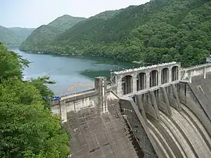
Maruyama Dam with Sosui Gorge behind it
References
Wikimedia Commons has media related to Maruyama Dam.
This article is issued from Wikipedia. The text is licensed under Creative Commons - Attribution - Sharealike. Additional terms may apply for the media files.